Lesser Antilles
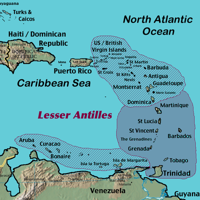
The Lesser Antilles, also known as the Caribbees,[1] are part of the Antilles, which together with the Bahamas, the Turks and Caicos Islands, and Greater Antilles form the West Indies. The islands are a long partly volcanic island arc, most of which wrap around the eastern end of the Caribbean Sea on the western boundary with the Atlantic Ocean, and some of which lie on the southern fringe of the sea just north of South America.
Contents |
Regional terminology
The two main groups of the Lesser Antilles are the Windward Islands in the south and the Leeward Islands in the north. The Windward Islands are called such because they were more windward to sailing ships arriving in the New World than the Leeward Islands, given that the prevailing trade winds blow east to west. The trans-Atlantic currents and winds that provided the fastest route across the ocean brought these ships to the rough dividing line between the Windward and Leeward Islands.
A third category which is part of the Lesser Antilles is the Netherlands Antilles. The Netherlands Antilles consist of two groups of three islands, one in the southwest (the Leeward Antilles or the ABC islands) just off the coast of Venezuela, plus a group of three more islands in the northeast (the Leeward Islands).
Geology
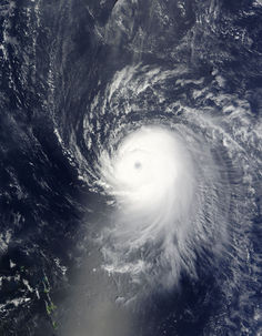
The Lesser Antilles more or less coincide with the outer edge of the Caribbean Plate. Many of the islands were formed as a result of the subduction of oceanic crust of the North American Plate under the Caribbean Plate in the Lesser Antilles subduction zone. This process is ongoing and is responsible not only for many of the islands, but also for volcanic and earthquake activity in the region. The islands along the South American coast are largely the result of the interaction of the South American Plate and the Caribbean Plate which is mainly strike-slip, but includes a component of compression.
Political divisions
Sovereign states
| Name | Subdivisions | Area (km²) |
Population (1 July 2005 est.) |
Population density (per km²) |
Capital |
|---|---|---|---|---|---|
| Parishes | 440 | 85,632 | 195 | St. John's | |
| Barbuda | 160.56 | 1,370 | 9.65 | Codrington | |
| Redonda | 1.50 | 0 | 0 | n/a | |
| Parishes | 431 | 284,589 | 660 | Bridgetown | |
| Parishes | 754 | 72,660 | 96.3 | Roseau | |
| Parishes | 344 | 110,000 | 319.8 | St. George’s | |
| Parishes of Saint Kitts and Nevis | 261 | 42,696 | 163.5 | Basseterre | |
| 93 | 12,106 | 130.1 | Charlestown | ||
| Quarters | 616 | 173,765 | 282 | Castries | |
| Parishes | 389 | 120,000 | 308.4 | Kingstown | |
| Regional corporations | 5,131 | 1,299,953 | 253.3 | Port of Spain | |
| Tobago | 300 | 54,000 | 180 | Scarborough |
Non-sovereign territories
Islands
The main Lesser Antilles are (from north to south to west):
- Virgin Islands:
- U.S. Virgin Islands: St. Thomas, St. John, St. Croix, Water Island
- British Virgin Islands: Tortola, Virgin Gorda, Anegada, Jost Van Dyke
- Anguilla (UK)
- Saint Martin/Sint Maarten (France/Neth.)
- Saint-Barthélemy (Fr.)
- Saba (Neth.)
- Sint Eustatius (Neth.)
- Saint Kitts
- Nevis
- Barbuda
- Antigua
- Redonda
- Montserrat (UK)
- Guadeloupe (Fr.) - the Guadeloupean archipelago is partially Leeward and partially Windward.
- Dominica
Windward Islands:
- Martinique (Fr.)
- Saint Lucia
- Saint Vincent
- Grenadines
- Barbados (Barbados is a Continental island found 100 miles east of the Windward chain)[2][3][4]
- Grenada
- Trinidad and Tobago (are sometimes considered part of the Windward Islands. They are the most southern islands of the Caribbean region.[1][5][6]
Leeward Antilles – islands north of the Venezuelan coast (from west to east):
- Aruba (Neth.)
- Curaçao (Neth.)
- Bonaire (Neth.)
- Los Roques Archipelago (Ven)
- La Orchila (Ven)
- La Tortuga (Ven)
- La Blanquilla (Ven)
- Margarita Island (Ven)
- Coche (Ven)
- Cubagua (Ven)
- Other islands (Ven)
See also
References
- ↑ 1.0 1.1 "West Indies." Merriam-Webster's Geographical Dictionary, 3rd ed. 2001. (ISBN 0-87779-546-0) Springfield, MA: Merriam-Webster Inc., p. 1298.
- ↑ Encyclopædia Britannica: The Windward Islands
- ↑ United Nations Educational, Scientific and Cultural Organization (UNESCO) | The Scotland District of Barbados
- ↑ CountryStudies.us | The Windward Islands and Barbados
- ↑ Cohen, Saul B., ed. "West Indies" The Columbia Gazetteer of North America. New York: Columbia University Press – Bartleby. Accessed: 19 September 2006
- ↑ ARBITRAL TRIBUNAL CONSTITUTED PURSUANT TO ARTICLE 287, AND IN ACCORDANCE WITH ANNEX VII, OF THE UNITED NATIONS CONVENTION ON THE LAW OF THE SEA IN THE MATTER OF AN ARBITRATION BETWEEN: BARBADOS - AND - THE REPUBLIC OF TRINIDAD AND TOBAGO - The Hague, 11 April 2006 (Pages 15-16)
- Rogonzinski, Jan. A Brief History of the Caribbean. New York: Facts on File, 1992.
| Name | Subdivisions | Area (km²) |
Population (1 July 2005 est.) |
Population density (per km²) |
Capital |
|---|---|---|---|---|---|
| null | 193 | 103,065 | 534 | Oranjestad | |
| Districts | 153 | 27,000 | 260 | Road Town | |
| Arrondissements | 1,628 | 405,500 | 249.1 | Basse-Terre | |
| Arrondissements | Fort-de-France | ||||
| Islands Shown below | 800 | 197,041 | 246.3 | Willemstad | |
| 444 | 180,592 | 406.7 | Willemstad | ||
| 288 | 197,041 | 246.3 | Kralendijk | ||
| 24 | 40,917 | 1,704 | Philipsburg | ||
| 21 | 3,100 | 147.6 | Oranjestad | ||
| 13 | 1,424 | 109.5 | The Bottom | ||
| null | 21 | 7,448 | 354.6 | Gustavia | |
| null | 87 | 5,700 | 65.5 | Marigot | |
| Districts | 346.36 | 108,448 | 313.1 | Charlotte Amalie |